Research goals
The term "smart cities" can be defined in different ways, but definitions almost always refer to using "smart" technology to improve various aspects of cities. In this context, GEO-C will use methods and approaches from Geoinformatics and its application areas to investigate open cities, i.e. smart cities that are open to all citizens and facilitate participation on all levels. A complex topic area such as smart and open cities clearly calls for an interdisciplinary and multi-perspective approach. GEO-C brings together key stakeholders from academia, industry, and government in a multi-disciplinary team (including, e.g., experts in spatiotemporal and environmental modelling, statistics, human-computer interaction, visualisation, information systems, mobile and ubiquitous computing, spatial learning, or decision support systems) under a coherent and effective structure.
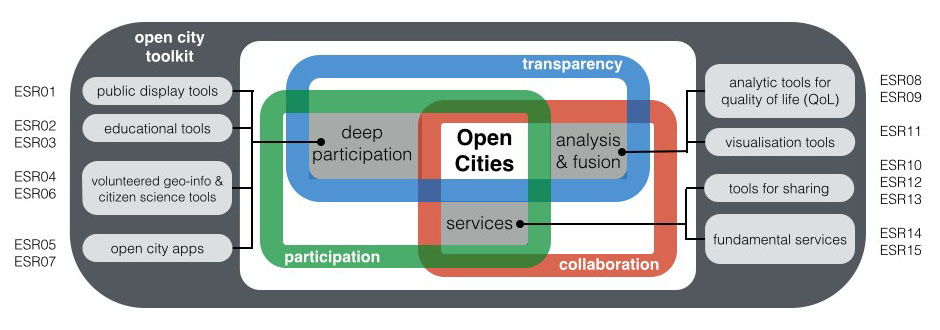
The main goal of GEO-C is to make substantial scientific progress towards the notion of open cities, i.e. smart cities that are open to all citizens and facilitate participation on all levels. In order to achieve this, we will (i) train the next generation of smart city experts in a multi-disciplinary program, (ii) address key challenges of rapidly changing cities with novel participatory technologies, and (iii) facilitate the implementation of open cities via a an open source toolkit. The research questions of GEO-C will be tackled in three complementary strands. They are derived from the three core areas in research on open governance: participation, collaboration, transparency (cf. figure below). Each strand falls into one of the intersections between the core areas and covers a crucially important aspect for realising open cities: deep participation, analysis and fusion of city data, and city services (cf. table below).
Research strands, main research questions and key outcomes
| Research strand | Deep participation | Analysis and fusion | Services |
|---|---|---|---|
| Research questions | How to enable all citizens to participate in and benefit from smart cities? | How to determine quality of life and key performance indicators of smart cities? | How to realise fundamental services in smart cities? |
| Overarching questions | How to enable all stakeholders to contribute to smart cities? How to facilitate transparency and openness of all processes, decisions and data in smart open cities? What insights can be gained from open data on smart cities, and how to best make use of such data? | ||
| Key outcomes | Methods and approaches to realise smart and open cities, prototypically implemented in an open source toolkit to facilitate uptake; fifteen PhD graduates with necessary skills and expertise to drive realisation of smart and open cities. | ||
The three strands also correspond to the three main research work packages, which strongly interact to account for the interdependency of the topics. The strands are connected via the overarching research questions and the common goal of developing an open city toolkit (cf. figure below). This toolkit is a key element in ensuring the uptake of methods developed in GEO-C. Each of the fifteen individual PhD projects tackles specific research questions in one of the three strands.
- ESR 01: Public displays as integrators of open cities, supervised by Kray (WWU, Germany)
- ESR 02: Educating children as citizens of smart open cities, supervised by Schwering (WWU, Germany)
- ESR 03: Using and adapting open citizen data for different user groups, supervised by Schwering (WWU, Germany)
- ESR 04: Volunteered geographic information, integration in public participation and geographic information systems, supervised by Painho (UNL, Portugal)
- ESR 05: Determinants of ICT for online citizen participation in city/urban contexts: implications of 2nd order digital divide, supervised by Oliveira (UNL, Portugal)
- ESR 06: Participatory sensing framework, supervised by Casteleyn (UJI, Spain)
- ESR 07: Mobile services for green living, supervised by Gould (UJI, Spain)
- ESR 08: Sensing quality of life, supervised by Pebesma (WWU, Germany)
- ESR 09: Climate change and impacts on the quality of life in urban systems, supervised by Costa (UNL, Portugal)
- ESR 10: Predictive analytics - human mobility patterns investigation from social networks, supervised by Henriques (UNL, Portugal)
- ESR 11: Multi-scale, multidimensional urban information integration, matching and visualization, supervised by Huerta (UJI, Spain)
- ESR 12: Spatio-Temporal Online Social Network Analysis, supervised by Mateu (UJI, Spain)
- ESR 13: : Proximity-based opportunistic information sharing and privacy protection, supervised by Kray (WWU, Germany)
- ESR 14: Use of social paradigms in smart cities mobile context-aware computing, supervised by Santos (UNL, Portugal)
- ESR 15: Situational awareness as a service, supervised by Granell (UJI, Spain)
While each PhD candidate is assigned to one of the three main research work packages, their work also draws on the other strands and contributes to a number of components in the toolkit.

The Open City Toolkit, its core components and the three main research work packages
The project will bring together three institutions that have a proven track record in complementary research areas of Geoinformatics with city councils and companies from three European countries. These associated partners will play a key role in shaping the open city toolkit and the underlying research. They will host one-month internships of the ESRs during their first year and support the requirements analysis for the open city toolkit. In addition, they will apply and use research outcomes in the development of their services and products. This will ensure that the topic of ‘open cities’ is tackled from multiple perspectives, that outcomes are relevant in practice and in academia, and that PhD researchers will acquire key skills to drive the implementation of open cities.
Warning: simplexml_load_string(): Entity: line 1: parser error : Space required after the Public Identifier in /users/apache/geo-c.uji.es/htdocs/right_contentRSS.php on line 17
Warning: simplexml_load_string(): <!DOCTYPE HTML PUBLIC "-//IETF//DTD HTML 2.0//EN"> in /users/apache/geo-c.uji.es/htdocs/right_contentRSS.php on line 17
Warning: simplexml_load_string(): ^ in /users/apache/geo-c.uji.es/htdocs/right_contentRSS.php on line 17
Warning: simplexml_load_string(): Entity: line 1: parser error : SystemLiteral " or ' expected in /users/apache/geo-c.uji.es/htdocs/right_contentRSS.php on line 17
Warning: simplexml_load_string(): <!DOCTYPE HTML PUBLIC "-//IETF//DTD HTML 2.0//EN"> in /users/apache/geo-c.uji.es/htdocs/right_contentRSS.php on line 17
Warning: simplexml_load_string(): ^ in /users/apache/geo-c.uji.es/htdocs/right_contentRSS.php on line 17
Warning: simplexml_load_string(): Entity: line 1: parser error : SYSTEM or PUBLIC, the URI is missing in /users/apache/geo-c.uji.es/htdocs/right_contentRSS.php on line 17
Warning: simplexml_load_string(): <!DOCTYPE HTML PUBLIC "-//IETF//DTD HTML 2.0//EN"> in /users/apache/geo-c.uji.es/htdocs/right_contentRSS.php on line 17
Warning: simplexml_load_string(): ^ in /users/apache/geo-c.uji.es/htdocs/right_contentRSS.php on line 17
Recent Posts
Acknowledgement
GEO-C is funded by the European Commission within the Marie Skłodowska-Curie Actions, International Training Networks (ITN), European Joint Doctorates (EJD). The funding period is January 1, 2015 - December 31, 2018, Grant Agreement number 642332 — GEO-C — H2020-MSCA-ITN-2014.


